

After the arrival of the Anglo-Normans in 1169, the monastic centre of Taghmon became a demesne manorial centre, probably as a result of its strategic position on the main road between the towns of Wexford and New Ross. Taghmon subsequently descended to Strongbow’s heirs, the Valences, Lords of Wexford. In 1233 a charter of deforestation was issued by Richard Marshall which permitted his free tenants to ‘clear, enclose and cultivate’ their lands which were within the ‘metes and bounds of the forests of Ross and Taghmon’ (Colfer 2002, 94).
An inquisition in 1305 heard that Agatha de Mortimer held ‘two carucates of land (which certain Irish held), three acres of meadow, a mill, five carucates of land (which the burgesses of the town held), worth £8, 3s, 7d a year’ (Hore 1906, 418). Another inquisition in 1323 records that there were 48 burgages in Taghmon, which generated an annual rent of 48 shillings (ibid, 412). A burgage was a type of medieval property plot that was generally found in a village or town and held in return for rent or service. It typically consisted of a long, narrow plot of land, with a house facing onto the street and the rear of the property accessed via a back lane.
In this context, it is interesting to note that the original name for Stream Street in Taghmon was Back Street (Ordnance Survey mapping) and this may represent a back lane that allowed access to medieval burgages, which fronted onto Main Street. Indeed, possible evidence for such a burgage plot was identified, in the form of medieval ditches and building remains, when a site stretching between Main Street and Stream Street was archaeologically tested in 2003 (McLoughlin 2003).
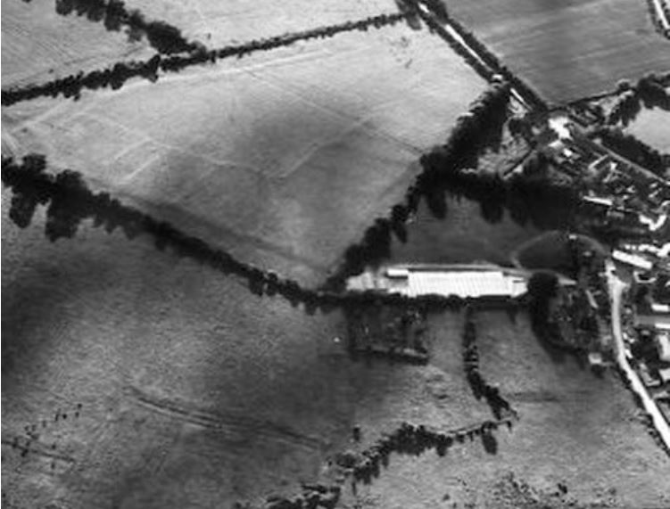
In 1358 an inquisition into lands owned by Roesia, widow of Robert FitzRaymund Meiler of Duncormick found her possessing 21 burgages in the western part of the town (ibid, 418-19). Possible evidence for these burgages can be seen in agricultural land on the southwestern periphery of the modern village. Here an extensive series of earthworks appears to show the remains of fossilised burgage plots. Visible on aerial photograph from 1970 and described as a ‘field system’ in the RMP[1] files, these earthworks are reminiscent of the ‘toft and croft’[2] property divisions often found on deserted medieval village sites in England (eg. Wharram Percy[3] or Little Oxedon[4]).
By the end of the 14th century the Anglo-Norman colony in Wexford was under severe pressure from an Irish resurgence and much of the northern part of the county had been abandoned. Taghmon was now a frontier town and in 1381 it was described as ‘on the marches of the county‘ and that 16 men-at-arms and horses had to be stationed there to curb ‘the malice of the Irish of those parts‘ (Hore 1906, 419). Taghmon’s pivotal position in defence of the southern Wexford colony was recognised by an act of Parliament in 1441 which called for the ‘building of tower upon the river of Taghmon in the country of Weysford’ (Colfer 2002, p. 241). Similarly in 1453 an order was issued that ‘none shall breake the fortifications or streyninges of Thamon in the Countye of Wexforde, nor shall make no waies on the same water from the wood of the Bannow to the pill adjoining to the river of Slane‘ (Hore 1906, 142).
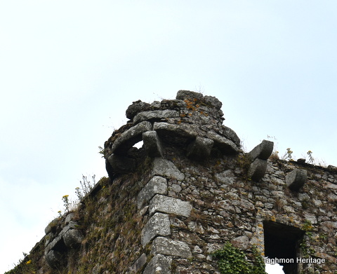
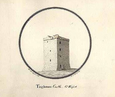
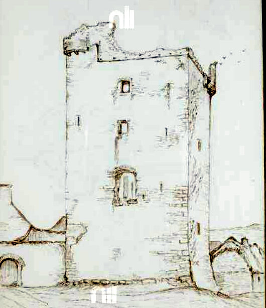
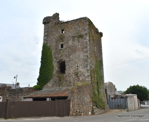
It is most likely that during this turbulent period Taghmon castle was built. Tradition ascribes its construction to the Hore family in the early 15th century, although the Talbots were Lords of the manor at this time (Power 2013, p. 13). Historian Billy Colfer has suggested that it may in fact have been erected by Sir Gilbert Talbot, when he was Lord of the Liberty (Colfer 2013, 108). The castle is one of the largest in the county and survives to four storeys in height. The doorway (now blocked) is defended by a machicolation, portcullis and murder-hole, while two corner machicolations, on the north-west and south-east angles, afford further protection (ibid, 79).
The castle was well needed as Taghmon was increasingly coming under attack from the Irish. For example, in December 1570 a group led by Edmund McTirrelagh killed ‘Dermit O’Cowan of Tamone’ with ‘swords and knives‘ and then with ‘force and arms’ carried off 80 cows, 12 horses and 10 domestic utensils‘ (Hore 1906, 421). Even worse was to occur in 1600, when Taghmon was burned and the surrounding country ravaged by the Gaelic Irish clans, The Kavanaghs and the O’Byrnes (Power 2013, 14).
Footnotes
[1] Record of Monument and Places
[2] The toft refers to the land on which the house was built, the croft is the adjoining plot of land used for pasture or arable. Generally seen as narrow parallel strips of land
[3] Beresford, M. W. 1990 Wharram Percy Deserted Medieval Village, English Heritage
[4] 7 Abandoned villages that can teach us about medieval life (https://heritagecalling.com/2014/08/29/7-abandoned-villages-that-can-teach-us-about-medieval-life/)
Bibliography
Colfer, B. 2002 Arrogant trespass: Anglo-Norman Wexford 1169-1400. Enniscorthy, Duffry Press
Colfer, B. 2013 Wexford Castles, Landscape, Context and Settlement, Cork, Cork University Press
Hore, P. H. 1906 History of the town and county of Wexford : The town of Wexford, with a chapter on Taghmon, and a short notice of Harperstown, the ancient seat of the Hore family, London
Orpen, G.H. 1934 Charters of earl Richard Marshal of the forests of Ross and Taghmon. Journal of the Royal Society of Antiquaries of Ireland 64, 54-63.
Power, V. 2013 ‘The medieval archaeology of Taghmon’ in in Taghmon historical Society Journal, No. 7, Wexford, Impression Print, pp. 7-16
McLoughlin C. 2003 Archaeological Assessment at Main Street/Stream Street, Taghmon. Unpublished report for Stafford McLoughlin Ltd.
Seery, J 2007 ‘Taghmon Castle Standing Sentinel for around 600 years’ in Taghmon historical Society Journal, No. 7, Impression Print, Wexfod pp. 31-34
